Monday, August 3, 2015

Sequoia and Kings Canyon

 In East Central California (as defined by me :)), lies two national parks which are connected and often visited together, Sequoia and Kings Canyon. My visit was mashed together and I often traveled back and forth, so I'll basically treat them as one in this post. I think this has been my favorite park so far. Yosemite is next on the list but even still, I liked this one. Maybe because Yosemite is so huge and so popular. This park is a little easier to manage size wise and besides a busy weekend, was much more serene than the main part of Yosemite. But I'll talk more on Yosemite next time. 

The star of the show is definitely the Sequoia tree. I've been surprised how much I've loved the trees in the different parks. The sequoias are HUGE!! The largest trees by mass that you'll ever see. The sad thing is that when they were discovered, they were harvested for lumber. So you see huge stumps everywhere that would be even bigger than the biggest currently alive. 

The first night I got in later in the day and was happy to still find a campsite open. I had to drive pretty far into the park, so all I could do that night was set up camp, have some food and head to bed. Here's my campsite - among some big trees (as compared to those in IL) and some bigger stumps. 


This shows how long it takes an old sequoia to grow.

This plaque just made me smile/laugh.

One of the stumps not too far from my campsite.

As you drive through the parks, you drive through some National Forest land too. Not sure if I've mentioned it previously, but some of the forests have good camping and trails in their own right. The forests are actually managed by the Department of Agriculture (forestry) whereas the parks, rec areas, monuments, etc. are managed by the Department of the Interior. Since they are managed by two different groups, it is hit or miss about how well coordinated the two are. I saw a sign for the Chicago Stump (see below) and ended up picking up a flyer about other areas in the forest. Otherwise I wouldn't have had any idea. Below are pictures from a stump forest I visited. The remains from one of the logging enterprises. Because the sequoias are so old and big, a couple of issues arose. First, it took a lot of work just to get the lumber in a manageable size. Second, the age of the wood caused it to not be the best quality lumber. The demand was not sufficient and eventually logging operations shut down. Some people also saw the benefit of these huge forests and were at the same time working to protect them, which was just another problem for logging.

If hollow, my car definitely would have fit inside this stump.

Selfies on the cell phone are relatively easy but I usually try to use the timer on my nice camera to get some pictures with me in them (where my head doesn't take up at least a third of the picture). I definitely still need practice ;).


I left the forest and headed to Kings Canyon. There's a nice hike to a waterfall that follows the river. The trail goes on further and you can do a 4-5 day backpacking trip between smaller lakes. I think that sounds awesome and was jealous of the groups I saw heading out.

Every once in a while, when no one is around, I try to get a jumping picture with the timer. This was my most successful shot, lol. Practice....


A little mouse I found on the trail. He barely moved until I was right over him.

Up to this point I was mainly hiking in my hiking boots or shoes. However I decided to wear my sandals this day. They are sturdy sandals (Chaco) but I ended up a lot dirtier than anticipated :). This was after I had rinsed off in the river about halfway on my return hike.

The Chicago Stump. I was curious. How was Chicago relevant out here? Turns out it was the biggest tree (they think it would be the biggest now if still alive) and some people thought it would be awesome to bring it to the World's Fair in Chicago that was coming up (sidenote: read Devil in the White City if you haven't already). So they cut it down, cut it into transportable pieces and reassembled it in Chicago. Apparently people still thought it was fake when they saw it in Chicago. If you want to get a feel for magnitude, look at the placard pictures, the top one shows the men sitting in the piece carved out.

And here's me with the stump today.

I often don't sleep more than one night in the same spot. It's nice when I do (my morning routine is much quicker) but usually I want to check out another area of the park or find somewhere cheaper. This spot only had five campsites and no water, but it was free :).

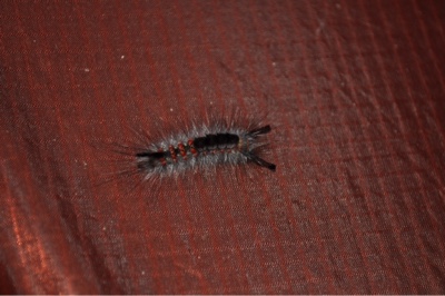
I found this funky caterpillar on the outside of my tent in the morning.


Then one day I just took a walk. I had tried to make it to a couple different ranger programs with no success. I always underestimated the drive time and/or parking situation. So when I missed one and had no plans, I parked, walked across the road and found a trail. It ended up being a great walk through a sequoia forest. Many of the trees were still relatively young but still pretty big :). The black on the trunk is from a fire. The sequoia actually need forest fires to survive. Their pinecones only open up after a fire has come through and destroyed the ground vegetation. Then the seeds are planted and they will begin to grow. Rangers didn't know this at first and for a while tried to stop all fires. Now we know the importance and they try to let natural (e.g. lightning) fires burn. The sequoia bark is super thick (up to two feet I think), so they can withstand most fires.

One tree had fallen and was hollowed out so that you could walk through it. That was pretty cool. I couldn't even touch the top in some spots.

A look up at one of the giants. (Redwoods do grow taller than sequoias but don't have the same girth and overall mass.)


This one had a sign in front, so I tried to do some perspective shots with my water bottle. Lots of trees were named for historic presidents.


The Lincoln happened to also have a mini tunnel on one side :).

Here's the full tree. You can barely see the water bottle. It looks like a glint of sun or something. But it's there, at the bottom, just left of center. (If you click on the picture, your browser may open it larger in a new window - not sure.)

There were other trees as well and they had some of the largest pinecones I've ever seen.

Here is General Sherman - the biggest tree alive.

Those are the Sierra Nevadas. Mt. Whitney is over in that area and is the highest peak in California at 14,494 feet. I did not feel a need to climb it :). But the John Muir trail connects Mt Whitney to Yosemite. It's one of the shorter long trails in the U.S. and hiking it is on my bucket list.

Friday, July 31, 2015

Joshua Tree

I originally hadn't planned to stop at Joshua Tree (JT). The park is just east of San Diego but far enough away that the climate is much more desert. I had other deserts on my itinerary and June didn't seem the time to be visiting deserts. Also, it wasn't really on the way anywhere. 

However, when I learned a friend's sister who I knew from high school was living in the area and she and her husband invited me to come down and stay, I easily changed my mind :). I was also ahead of schedule since I didn't spend very long at the Grand Canyon. Unfortunately, I failed to get any pictures of Tara, Bret and me. :(

I was there during the week and Tara had to work during the day but Bret was free and was previously an interpretive ranger at JT (Tara was too - they've worked at tons of parks!). So Bret was like my personal guide each day. 

We started at an oasis Tara suggested. You know, like in movies, the pond of water in the middle of the desert? There wasn't standing water but you could tell it was just below the surface. It went from sparse desert plants to big palms and other trees and plants. It was pretty cool. Also, those palms are the native California palms - a little different looking to ones you might see in town (the imports). When travelers saw big trees like this, they had a haven during their trip. It was amazing the drop in temperature when we entered the oasis. 

You could follow a sort of wash or dry creek bed and see where the trees followed. That's where the water was.

On the walk out, we saw a dead (and later a living one buzzed by) tarantula hawk. Remember that from my Big Bend stop? Well this looked more like the picture I'd seen and Bret confirmed it. It doesn't look like a tarantula, so why is it called that? It's the tarantula predator...sort of. The Hawks have huge stingers (so avoid one landing on you) which aren't harmful to humans but apparently hurt like you can't imagine. Super painful. But, it flies down and stings the tarantula, paralyzing (or killing?) it and drags it back into the tarantula's hole. Then it lays its eggs inside the tarantula. The eggs feed on the body of the tarantula until they're ready to come out and start the process again. Pretty crazy Mother Nature.

We also saw one of the biggest lizards I've seen in the U.S. so far. Probably doesn't look that big here, but it was more iguana size than newt size.

The cactus garden of the desert :).

This is one of those cacti close-up. They look harmless but are super painful. Each of those spines has a covering on it. When it sticks into something or someone, the covering comes off and a spine full of barbs sinks into you. It is painful to take them out. And as you can see, if you take a spill onto one, you're going to get a lot more than one spine in you. 

Here is Skull Rock. JT surprised me in that there are lots of rock formations and a fairly big elevation change within the park and desert. These rocks are basically the tops of much larger rocks, still underground, that are showing due to erosion.

A lot of the rocks look smooth and have lots of cracks. It gets cold here and water can freeze and unfreeze. You can see the balanced rock/boulder on top of this rock formation.

The rocks here are great for climbers. I don't climb but both Tara and Bret do. He was telling me that in the winter, when Yosemite is covered in lots of snow (aka the climbing Mecca which I will visit later), climbers come to JT where the sun and heat are a bit milder than during the summer. So there are lots of climbing opportunities. I did not attempt any :).


An overview from one of the high points in the park. Bret told me the mountain ranges you see in the distance, but I forget.

One day we hiked Ryan Mountain and had a nice lunch all to ourselves up there.

They use to ranch cattle here - or at least move them through. Therefore they needed water...in the desert. They would find a valley surrounded by mountains and dam up an entrance. You can see the old water high mark still on the rocks.

Writing in cement outside the dam.

And least but not least, we got to the JT forests. The park is named for the Joshua Tree. Probably more cactus than tree, although it appears more tree like. Similar to the Saguaro, it takes a long, long time for these to grow. And they are sensitive to the climate - they are not seen throughout the park because the park has a pretty big elevation change and therefore climate change. They are worried if the trees will disappear as climate change continues to impact earth.

Usually they stay low, but like humans, every one is unique. This is a super, super tall one.

I stayed with Tara and Bret for 3-4 days and had a great time. It was so nice of them to extend the invite when they saw I was in the area (i.e. northern Arizona, lol). Since they are park geeks too (I think I'm becoming one, if I haven't already), it was also lots of fun to talk about where I'd been, where I'm going, where they'd been and where we all want to go :). 

Next up, my favorite park so far!!

Tuesday, July 28, 2015

Vegas, Baby

Some people are a bit shocked when I tell them I've never been to Vegas. Well, now I have. My first rule about going to Vegas will in the future be 'don't go solo'. I mean I still had a nice time but I think you need to have company for it to really be enjoyable. 


I crossed the state line and of course had to stop at the engineering marvel that is the Hoover Dam. Notice the lake behind the dam. See that white ring? That's where the water level was previously. You know that drought mentioned out West? Here's evidence. I think the lake is half or one third of its previous level.


I'm not sure what I expected but it was a bit of a let down. Parking was like $10, so I opted not to go down to the actual dam. Instead there is a new memorial bridge that is on the side of the highway and provides a far-away view of the dam and Lake Mead behind. The stories of the two men to whom the bridge is dedicated were interesting. One from Arizona and one from Nevada - both Veterans. Google Mike O'Callaghan and Pat Tillman if you're interested. 


I stayed at a nice place - the Hilton Vacation Club behind/sorta attached to the Flamingo. I checked out both pools for sure :) a relaxing couple of days.

I did the obligatory evening stroll down the strip to people watch and catch the Bellagio fountain show. It was pretty cool and seemed like it is different throughout the night. I caught a Cirque show as well. I didn't have a bad time by any means, just think it would be better to have a partner in crime ;).