Friday, October 31, 2014

Gettysburg

I have been very lazy. I was trying to not get more than a month behind in the blog, yet each day I let it slip farther past due. I've been home this week and will be next. I've learned that being unemployed and at home is not a good mix for me :). I don't do anything. Super slacker. And while I know I should do things, the next day is usually similar to the last. So while I told myself I'd be practically caught up at this point, I am more behind than ever. Clearly my next job will not be as a blogger as it always loses out when up against Netflix :). The one thing I have done --> I have managed to better solidify my itinerary in Europe that starts in less than two weeks. (YAY!) 

Back to late September...

I got to Gettysburg late in the day. The visitor center closed just as I arrived but luckily Google helped me find a map to follow and drive through the battlefield while I still had some sun. 

Gettysburg was a much, much larger battle than Antietam. While I followed the posted markers, it was hard to picture how things went down. I made it to Little Round Top, which was one of the areas I did remember from the movie Gettysburg. Then I took off to find the nearby KOA and get my tent setup. 
Wide open fields that are still farmed today

View from one of the Round Tops


In the morning, I headed to town for breakfast and then on to the visitor center. There are all sorts of tours available and if I had the time and maybe a couple more people to share the cost, I would have hired a guide to join me in the drive around the battlefield and provide live commentary. Instead, I watched the movie and cyclorama and attended the free ranger walk/talk that was an hour or more. Ranger programs are always the way to go I'd say. It was great, he walked us to the main battlefield along Cemetery Ridge. It was very interesting, though I'm not sure how much of the detail I retained. 

The ranger was helpful in describing the scene so you could picture it better. There are forested areas around Gettysburg, but imagine that all the underbrush has been cleared as most of the land was either farmed or used for livestock. There were thousands of men and all needed water and food. Gettysburg was a great location for this battle because it is an intersection of 10 roads in one spot, so easier to maneuver troops and supply lines. There was water, though by the time all the men converged, the running creeks wouldn't be able to sustain their needs, the needs of animals and remain sanitary after the bloody days of war. 

We walked by a widow's house which was taken over by Union leaders. Imagine your house becoming the target for the enemy, the artillery shells falling all around it, eating all your food, raiding the garden, demolishing your winter stores, slaughtering your farm animals. All the officer's horses also feeding and drinking at your house, not to mention pooping (and horses poop ain't small). Your picket fences are torn down to provide wood to the soldiers. Then, when the artillery shells do get close, you have dead horses all around. The ranger said there would have been 16 dead horses and men left all around this lady's house. Yet she stayed throughout and after the war to put it back together and live out her life. Imagine trying to take care of one dead horse, much less 16.  And I'm sure that wasn't first priority, so you can imagine what it was like after only a few days.
Widow's house

Standing on Cemetery Ridge with the town to our right, we looked left towards Little and Big Round Tops. See picture below. While the two hills don't look much different today, they attacked at Little Round Top because it had been logged back in the day and was clear whereas Big Round Top was still covered by forest. Along this ridge (you can't really tell but the land off-camera to the right was lower), was the union Army; from where I stood (even behind me) out to the end of those hills.
The Round Tops off in the distance beyond the domed memorial (Pennsylvania I think)

Gettysburg was the bloodiest overall battle, lasting three days. This battle was all uphill, the Confederates charging on Union soldiers. It is hard to imagine how you would have felt this seemed doable. Some of the uphill was gradual but still must have been daunting. Soldiers would on average travel 12 miles per day when on the move. If pushed, they could achieve 28 miles in 11 hours. 

The park ranger was excellent and the museum inside very interesting. The store of souvenirs is ridiculous. They must have anything you could think of! Here are some wikipedia facts that I didn't retain (from nps.gov/gett/):
When - July 1-3, 1863
Union Leader - Major General George Gordon Meade (Army of the Potomac ~93,000 men)
Confederate Leader - General Robert E Lee (Army of Northern Virginia ~70,000 men)
51,000 casualties (dead and wounded)

Examples of soldiers

General information on the battle
What makes an army

Me and Abe 

The National Park Service is working hard to restore the battlefield to a more original setting - planting trees in certain areas and even moving the visitor center so that it can't be seen from the battlefield.  However, in the orchard, they did use a variety of fruit (peaches I think) that do not require/attract bees in order to make it more pleasant and less risk of a bee sting to the public.

Definitely recommend Gettysburg!!

Tuesday, October 21, 2014

Fallingwater

After Antietam, I had decided to take a little detour to western Pennsylvania to visit Fallingwater, a Frank Lloyd Wright house. I was curious and didn't think I'd have another opportunity. You couldn't take pictures in the house at all, only outside. And you could only take a couple and they all started looking the same.


The house was built late in his career and was for the Kauffman family, who I believe owned Kauffman Department Store in Pittsburgh. They found some property they loved with a creek and they wanted the house near a certain spot to enjoy nature and the water. They imagined a house overlooking where the creek made a waterfall and pool over some boulders. FLW instead integrated the house with the water, placing the house essentially in the waterfall, utilizing the boulders in the foundation (and as part of the hearth) and the living area had steps down into the creek through a beatiful set of glass doors in the living room floor.

To be honest, at first glance I wasn't too impressed. But then the tour revealed all the little things that were just marvelous and I think made the house. The house is currently an ongoing restoration project as parts of the whole house seem to have been rebuilt at certain points.  

There was no air conditioning, but the glass panel "doors" in the floor of the living room opened along with many windows to provide great cross ventilation. The corners of the rooms looked out over the creek and had windows spanning the length of the room, no walls and corner supports to interrupt the view. The corner windows that ran vertical in the kitchen and bedrooms opened and you had the gentle sound of flowing water to fall asleep to. There were even cutouts in the desks to allow the windows to swing open, so you always has access to the outdoors and fresh air. 

The bedroom doors were beveled to keep out light around the cracks in the door. Closet shelves were thatched to keep clothes ventilated as well. Bathrooms had cork all over, walls and ceilings. The bedrooms each had terraces double or triple the size of the room to coax you outside rather than sitting indoors. There was also a guest house and a spring fed pool in case you tired of the creek. 

There was so much thought put into it, I really enjoyed it. If you find yourself in southwest Pennsylvania, I definitely recommend the house tour although in summer I hear the tickets sell out well in advance, so you may need to plan a little in advance depending on the time of year. I luckily was able to get a ticket the same day. 

Driving the backroads in PA was fun too. I found this super tiny community (like 50) that had cute shops and cafes. It was near a state park and seemed to cater to outdoor enthusiasts. It seemed like southwest PA may be a good place to head for kayaking, hiking, biking, etc. Unfortunately I didn't have too much time because I was headed east to Gettysburg and needed to get there before sunset to set up camp. 

On to Gettysburg!

Thursday, October 16, 2014

Great Falls National Park, Antietam Battlefield and Family

I was on my way to Alexandria VA where a college friend lives with her husband and kids. The last time I was there, they had a recent addition to the family. Now she was two and a half and a big sister. I actually ended up staying with them two weekends in a row and am just amazed how they handle it all.  I'll post more on our weekends together later. 

Monday after the first weekend (September 22), I was headed towards New Jersey to see some other friends and needed to get my plan together. It's usually only a day or two beforehand that I look at the maps to determine my route, and then it always seems to change a little along the way. Thank goodness for my car's navigation! I decided on Great Falls National Park and then heading to Antietam, my first battlefield visit. 

It was Monday, so I waited for morning traffic to clear and was still one of the first to the park in northern Virginia. All over were these signs about danger and not to go into the water. I feel like a lot of people must drown in this area. The water was very clear and looked pretty deep in places. There are three viewing platforms to see the falls and rapids which are just amazing to see the force of water. Then there are plenty of trails to walk as well. I went down one that takes you along the bluffs/canyon, high above the Potomac. You could see people on the other side as well, just sitting in the sun, enjoying a beautiful view. On the return trip, I hiked along the old canal. There use to be a system of locks to move boats down the river while sidetracking the rapids. It was really neat. 


During this time, I was texting my aunt and uncle from Milwaukee. I had talked to them at the wedding and they were going to be on vacation in the same area. I let them know I planned to visit Antietam later in the day (targeting 1pm) but it looked like I would just miss them as they were headed there that morning and then were off to other places. Unfortunately, it probably wouldn't work out to meet them. 

I kept walking around - the weather was perfect, beautiful, sunny, cool breeze, not too hot. I probably didn't end up leaving until almost 1pm. 

I got on the road and it of course took a little longer than planned, so I probably arrived to Antietam around 2:30. I actually headed for Antietam Creek as there were suppose to be some campgrounds nearby and easily accessible. I wanted to head there first to check it out so that I wasn't pressed for daylight after visiting the battlefield. I found the campgrounds. Looked pretty nice and completely empty. It was not manned, but there were reservation slips that work on the honors system and it was $10/night. Perfect :). I figured I had plenty of time and options since it was empty and headed into town (Sharpsburg, MD) to tour the battlefield. I was stopped at a light and saw a car coming from my right and they made a left turn in front of me. Hmmm...that driver looked like my uncle. The plates were Wisconsin. Could it be? I called my aunt and asked if they were at Antietam. She said they were on their way and I told her that I thought she was in front of me! Turns out she had texted me their change in plans but I hadn't seen it and just happened upon them. Sort of a planned, yet unplanned meeting :). 

We watched the movie inside that set up the history of the Battle of Antietam, the bloodiest two day battle of the Civil War. We also went around the museum area and the viewing area that tries to point out key landmarks. The battlefields were quite large, so the parks program also has a self guided driving tour that helps you move around, get closer and get a better field for the battle. There are also lots of monuments along the way for those that fought and died in the battle. My aunt and uncle had been to Gettysburg before and mentioned how this was a smaller battlefield and made it easier to conceive what really happened. So I was glad to have started here and left Gettysburg for a later day. Although it still is not the easiest thing to picture cornfields as battlefields. :)
Here's a good map from HyperBear.com:

We went for dinner in town and they got on the road to Baltimore and I headed back to the campground. 

This was about a month ago. It was nice to meet family and have someone to tour with rather than doing it on my own. It was especially nice because my uncle was what I would consider a history buff. He had added info and provided some perspective on what was going on. In recent years he had gotten into battle reenactments and was part of a medical team. I've forgotten the official name/title, but he shared lots of stories that afternoon from those events. There were some medical instruments in the museum he showed me. He talked about some of the differences between the Confederate and Union groups (he had uniforms to act in either role). Over dinner he shared some of the tactics to demonstrate wounds and caring for them, even how they simulated a limb amputation. Their next engagement was down in Georgia, right around the time I'd be travelling from Florida to Texas. 

Today I'm flying home for his funeral. While in Georgia, he suddenly passed away. It has been such a shock to my dad's family and me.  I haven't spoken with my aunt or my cousin but I can't imagine what they are going through. He was always full of energy, had lots of smiles and would try to get a good laugh from whoever was around. He will be greatly missed. 


Tuesday, October 14, 2014

Back in the USA - Shenandoah National Park


had about 10 days once I was back in the US before my brother's wedding. I spent a weekend in Peoria catching up with friends and had a little party that was lots of fun. I even took my bike for my first street ride...8 miles! I was pretty nervous and had some issues stalling it a few times, but overall a success. 


Then it was wedding time and we got all did up for our first traditional family wedding (we had one elopement!). The photographer releases pictures later this month and I'm excited to see them all. It was a beautiful day and everything went wonderfully. I took a day or two to recover and then got on the road. I was headed towards DC to visit friends and went via Shenandoah National Park in western Virginia. 

This was my first camping outing since back in the US and it was bear country. Gladly I didn't see any bears as I was a little nervous. I did however have two deer right next to me in the brush as I put my tent up. They were not phased. I also saw one rabbit in the morning, but that was the extent of my wildlife sightings. I did use the bear box to stow my food and scented gear so as not to attract unwanted visitors. You have to stick your hand up in the handle area to release the doors and my biggest concern was a spider :). 
The deer and my bear box

The spider in my bear box


There were no other campers in my loop of sites although there were plenty of other campers nearby in the campground. Mostly RVs and trailers. I built my first small campfire with collected wood, twigs, etc. I did have to use some paper garbage to get it started though. And then my clothes reeked of campfire smoke. Oops :). The temps were down in the 40s but I stayed plenty warm and comfortable.
Campfire!

Home for the night

I arrived late in the day, driving south to north through the park. The next morning I drove to the visitor center and got a good recommendation on a hike that would take me to early afternoon. The trail  followed the river/creek and I had lunch on some big boulders in the cascades. It wasn't very crowded but was very tranquil cascades (mini rapids), waterfalls and some pools of water. I purchased a Fitbit as I thought it would be fun to track (my friend Mary had the stats from the Inca Trail and that was pretty neat). 

Good morning!


My hike plan
Waterfall

Fitbit daily stats: 15,440 steps, 6.53 miles, 107 floors

There are tons of hiked here and the leaves were just staring to change. If I had more time, I would have loved to stay longer. But on to DC (Alexandria VA actually) to see friends and their new six month old twins!
A preview of the twins and their big sis :)

Wednesday, October 8, 2014

New trip, new country.....Peru

The hike in Scandinavia was awesome, even with the troubles. I would do it again for sure. It also helped prepare me for my next adventure....hiking the Inca Trail to Machu Picchu in Peru. This is a long post with lots of pictures - so hope you have a few minutes :).

A brochure of our four day hike that illustrates the distance and elevation

This trip would be different. We were a private group of friends and friends of friends. There were nine of us and all of a sudden I became the most experienced backpacker. First though, I had to get there. I had one night in Sweden before I boarded my 6am flight in a town up north, Kiruna. Land in Stockholm and hustle to my connection after rebooking luggage.  9am departure from Stockholm to Newark. Had about two hours in the US before boarding my flight to Lima, Peru. I arrived in Peru at 10pm the same day, just a few time zones go the west. Long day :). 

My friend Mary was there already and I met her at the hotel. She done a bit of exploring the day before and the next day we hit up the mall for a new water bottle (I left mine at security in Sweden accidentally), did some much needed laundry, had amazing ceviche and other local food at lunch and some churros con chocolate later in the day. It was really nice. The next morning we flew to Cuzco where the rest of our party had gone directly during the night and early morning. 

Laundromat
 
Ceviche and tacu tacu (rice and bean dish with seafood) for lunch
Paragliding along the coast in the cloudy weather of Lima (we just watched)


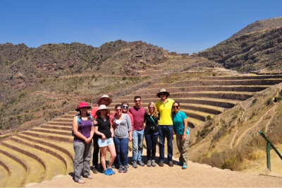
We had a couple days to explore Cuzco and acclimate to the altitude. We did a tour of the Sacred Valley and saw Inca ruins, I went to Sunday mass at the cathedral, we did some last minute shopping and gear check. It was weird going from the least experienced person (Sweden) to the only person who had done a multiple day hike. I shared my knowledge learned and maybe too much in some areas (bathrooms in the backcountry). 
Narrow streets of Cuzco 
Traditional dish of guineapig, which was pretty good (they brought it back cut up and sans head)
Cathedral in Cuzco 
We visited and fed grass to llamas and alpacas on the way to the ruins
Our guide for the day showing us how to get the animals to pose for a picture with us (I can't remember which were alpacas v llamas)
They demonstrated how their wool was used to make things 
Our group at one of the ruin sites
Our guide showing us how potatoes are harvested and dried for the winter - after being out overnight, you can squeeze them like a sponge to remove the water
Here's a local lady who uses her feet to squish the water out 


We did a final group dinner, packed and were ready for our 4am pickup the next morning. However I started to get a sore throat and very tired that night. I didn't sleep well and by morning was with a sore throat, congested and very tired. The guide looked at me and said sinus infection...we will stop at the pharmacy. We did and I got amoxicillin pills in a very quick and cheap transaction. I got better with each day and was thankful for the stop. I think I may have had a fever that broke on the second night as I almost passed out hiking the last bit of that day, had no interest in anything but crawling into my sleeping bag and woke up soaked in sweat in the middle of the night when it was maybe 35-40 degrees out. 

It was a four day hike - very different from Sweden. We hiked two to three times the distance, much higher elevations, carried little weight and did no work. There were like twenty porters that came with our group of nine and two guides. These porters are amazing. They practically run up and down the mountains with as much as 60lbs on their backs....and these are Peruvian men who don't have a very large stature. They may do 70 trips in a year! They were amazing and always had a smile. It was fun to see them pass us on the trail, laughing and joking around. The chef was pretty top notch as well. We had soup and hot drinks with every meal. There was chicken and beef, rice and quinoa, potatoes and even a birthday cake. The spread each day and night was very impressive, especially after what we had cooked in Sweden. 
Porters getting their packs ready and carrying a bunch of our stuff too
Brian and Mary ready to go
We stopped for an early break and the porters passed on by
All of them in a train
The cook's portion of the tent
Our jumping picture at the highest point, which I think is Dead Woman's Pass
I made it!!
Another view from our third day


A couple people in our group got altitude sickness too, one really bad. I don't know how he made it because he had no food in him. The second guide stayed with him and carried his stuff but I can't imagine the mental strength to continue with the physical efforts. On our last day we were up at like 3am to get an early spot in line for the entrance to the trail of the Sun Gate.  Our group was second. I've never hiked so fast and I maybe kept up for the first hour. Then I needed to shed some clothes and catch my breath and they were gone. I think I will always just be the slow hiker. But I made it, crawling up a rock wall halfway through, using my hands, and ultimately reaching the Sun Gate to see......clouds. Lol. We could see some of Machu Picchu but it wasn't the picturesque sunny view on the postcard. We didn't care though - we did it and the view was perfect for us! We spent the morning touring Machu Picchu. It was so impressive and amazing to think what they accomplished and then were pretty much wiped out as a civilization. 
Cloudy view of Machu Picchu 
Our group - we made it!! And the clouds are starting to clear a little
One of our guides, Edy, as we toured Machu Picchu 
The structure were built without mortar, perfectly carved blocks stacked up - so impressive
Our group
Machu Picchu 
Aerial view of Machu Picchu from the mountain next door 
The mountain next door is on the right, I only made it halfway; two people went all the way and it gets crazy steep and scary


The next day we took the train back to Cuzco and I said goodbye to everyone because I was staying a few more days. I took a day tour to see another Inca ruin as well as some old salt mines. I also took a cooking class and spent more time exploring Cuzco. I had an extra day in Lima and went to the Cathedral and explored in that area. Then the long trip home. 
The specks you see on the upper rings are the tourists - they think this was used for Ag research 
You can just see the steps that are built into the sides as long stones sticking out
Me at the salt mines, all done by hand and mostly used as a tourist attraction now
The local families in town each own several of the mines and earn money from them. They are fed by a small spring from the mountain that is 70% salinated (so I was told, as compared to the ocean at ~20% salination). 
A local artist I bought a picture from - one of the birds
The chef from my cooking class
Grinding my own quinoa flour for the soup we made 
Lomo saltado! A beef tenderloin dish with tomatoes and onions over fries. 
A mural in Cuzco 
Inside the Lima cathedral - bamboo is at the base of the structure to help protect against earthquakes
Outside the Lima cathedral
An archway into one of the 'tombs' in the cathedral - not my best side but gives some perspective on size
Skulls found under the altar

It was a great trip - one of those bucket list items. I loved the Peruvian food! I also dusted off my Spanish skills and was pretty comfortable in my ability to get around, though a little rusty. Definitely built confidence for any future trips to Spanish speaking countries.