Monday, July 27, 2015

Grand Canyon

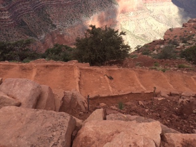
I headed to northern Arizona to see the famous Grand Canyon :).


I think the canyon can be hard to appreciate because it's so dang big. You see the vastness, can barely see the other side (I was on the more popular South Rim) and can't always see the river that looks so small you can't imagine how it truly created this. There is a trail you can hike from one side to the other that is roughly 22 miles and you start on the North Rim because it's 1,000 feet higher. Some big time hikers try to do that in a day. A ranger told us just within the week prior someone tried and didn't make it. They had to camp out 1-2 miles from the top of the South Rim. It's difficult because the climb up is pretty steep. They tell you not to try a down (to the river) and back in a day. They also suggest you start hiking as early as 4am. Because when the sun comes up, it gets hot and stays hot. The rocks at the bottom of the canyon heat up all day and keep baking you after sunset like an oven. I stayed sufficiently cautious :).

I got in late in the afternoon the first day and headed to one of the ranger talk locations to hear about California Condors. One the way I met this gal (elk are all over the park).

On my way out, I stopped by the visitor center. It was closed already but I usually stop to see what information is available. Especially at more popular parks, there's a lot of info outside to help you plan. When I saw the temperatures posted, I knew I had hit the weather jackpot. Early June is not usually a high of 70. Also, this is the temperature at the rim. The temperatures at the bottom of the canyon are 15-20 degrees higher. 


Back to the condor program. I like big birds. I don't know why but they interest me. The condor did not disappoint. First, the condors went extinct. Well, the last 22 were captured in 1987, so officially they were no longer in the wild. But they're back! Everyone worked really hard to ensure the remaining birds reproduced. People would even step in to help raise the baby birds. Here is the ranger with a condor puppet used to feed the babies....give them meat or just distract them while meat is thrown into the nest.

Condors are HUGE. The biggest bird in North America. The ranger showed us. First she said that if a condor would sit on the ground next to you, it'd be up to your waist (if you're an adult). It weighs almost 30 lbs. And the wingspan is long. She pulled out a tape measure and started naming off birds at different lengths, hawk, vulture, eagle. The longest though is the condor at almost 10 feet.

Fortuitously, there were two condors flying around the rim just near where our talk was. But they were all captured? Almost 30 years ago, yes, but since then, they've been reintroduced into the wild because of the success in captivity. Now there are over 400 condors. Researchers tag them and keep good record of where they're sighted, who they mate with, which offspring belong to them, etc. If you see a condor, on the bend in their wing you may also see a number (with your binoculars) on the top and bottom of the wing. Once you know the number you can find a whole history on that specific bird. Currently they've been reintroduced in California and the Grand Canyon (and are seen across the four corners region - being the intersection of AZ, UT, CO and NM). Below are the two condors. Pretty far from my camera, so I was glad the ranger set up a telescope so we could actually see the birds :). They are sitting on the ledge or outcropping that you see towards the middle of the pic. A black speck.

I actually camped in the Kaibab National Forest. It was full, but a bit secluded outside of town. Because so many people visit the Grand Canyon, the park is busy. They actually provide bus transportation and won't let you drive on some roads. The buses even come to the town just south of the park and near the forest campground. I thought the bus was super convenient. Because it was so busy though, I decided to shorten my stay to two nights. The next day I would hike and sleep before I hit the road early. 

One of the visitor center billboards showed a good map of the South Kaibab Trail that I hiked. This was a ranger led walk down to the Cedar Ridge rest stop, so only about a third of the way down into the canyon. However, based on the temperature/weather, time of day (although we only started at 7am) and a new willing friend I met, I went on to the next rest stop at Skeleton Point.

I was worried about being late, so I was awake before sunrise and almost an hour early to the trailhead. Lance was our leader and led us down into the canyon. This also happens to be the pack mule trail and so the trail smelled a bit different than I expected at some parts :). The Grand Canyon is made of many layers of rock going back a couple billion years. The Colorado River cut the canyon. The water cuts deep and then erosion helps clear out the wider top part of the canyon as the supporting rock underneath is carried out by the water. This takes a really, really long time :). The was also a point in history where a big hunk of land, called the Colorado Plateau, was lifted upwards from underground forces. Which is why the Grand Canyon rim is at an elevation and the river cuts over a mile below to the floor of the canyon. I think the South Rim was around 7,000 feet elevation.


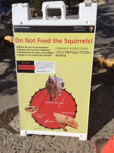
We finished our guided walk to Cedar Ridge in an hour or so I think. You'll see those clouds in my pictures above. Those aren't typical for this time of year. Rain is not common. Usually temps are a lot warmer. So if there was a day to continue on, I had it. The one thing to remember is that going down in the beginning is so much easier. And cooler. You start the climb when the sun is on you and you've been hiking for a couple hours already. You still have a long way back up :). But, my new friend Kristi said she would be up for it if I was, so we continued to Skeleton Point. Only later did I see the sign below. We had picked the most difficult day hike in the park :).

Squirrels. They are everywhere and like the human food. I found this to be common across the parks. If you set down your backpack, keep an eye on it. Those squirrels are dangerous.....

....they apparently carry the plague!?! I didn't know the plague still existed. Within the last year, someone (a ranger or park worker I think) was bitten and died from the plague. Serious business.

We had our rest at Cedar Ridge and avoided the squirrels. Then, we headed down to Skeleton Point and arrived just as the clouds started rolling in and looking ominous. When I saw lightning and had metal trekking poles in my hand, I was ready to head back.


It was pretty amazing to see the storm, the very rare rain storm, roll through (and mostly evade us). You could see parts of the canyon go black and then light up. I'm not sure if the pictures truly capture what it was like. It mostly rolled past us....the first part at least :). As we were up the trail, it started raining harder and luckily there was an overhang for cover to wait it out. And I was glad we did because it began to hail, maybe just larger than pea sized. Here's Kristi in our waiting spot. 


It didn't take too long to pass over and as we were almost ready to start climbing again the pack mules came. There's a cabin below, so they carry down supplies and carry up garbage along with backpacks for hikers who don't want a heavy load.

We continued on. Then I spotted it. California Condor. I was so excited I knew how to spot it (they are often confused with smaller vultures). Never got close enough to see the tag number though :(.

Here it is perched on the rock. It gives a little better idea of the size. A little hard to spot at first, it's about in the middle of the picture on the rocks (could only see the back of it).

Then it took off soaring. Probably looking for food. They are like vultures in that they eat dead meat.

We were done by about noon. It was weird to still have most of the day left after you'd done a big hike. I went to the other end of the park on the South Rim and found a good view of the river from there.

It was a great day spent at the canyon and I think a trip down to the floor would be pretty awesome. We met one guy who had hiked with a group for four days along the river. It sounded great, though he said it was super hot and a rough climb up on the last day.

Saturday, July 18, 2015

Flag(staff) and Sedona

I was told the "cool" people refer to Flagstaff as Flag. I have no idea if it's true :). Flagstaff is just north of Sedona and both seem to be the midway point between Phoenix and the Grand Canyon. I had heard there was great hiking in the area and Flagstaff was suppose to be pretty funky...a hippie town of sorts. I also needed a new headlight in my car which had been discovered back in Tucson when I got my oil changed. Side note: that was probably the most expensive oil change of my life. I usually stick with a Ford dealer and decided to go the 15 minute oil change express route. Never again. I don't know if I was taken or if they are just expensive in Tucson. End side note.

Luckily the Flagstaff Ford dealership is a couple blocks outside the historic downtown area. Tons of cute shops and restaurants. I explored town and bought a new belt while they checked out the car. They'd have the parts tomorrow and I decided to check into a hotel for a night. Laundry and shower time :). Not to mention catching up with the wifi. I did more shopping, exploring and eating the next day while the headlight was replaced and subsequently the tail lights as well. They also removed my cabin air filter and gave me a new one. I'm thinking this could have been cause of my recent sinus issues. 

I really enjoyed my break in Flagstaff. Great weather - cooler because it's up in elevation which also meant a little more green. Definite outdoors vibe and seemed like lots of fun things to do. If you're in the area, explore the town of Flagstaff instead of the more touristy Sedona. 

But go to Sedona for the hiking :). There is hiking in Flagstaff, but I get lazy when I'm not camping and walking around town had been enough for me. I moved on to Sedona though and did some great hikes. Sedona is touristy and expensive as well. I'm happy to report that I made it three nights in Sedona and only spent about $10 - $4 shower one day and $6 in ice and candy :). In the National Forests there, you can find spots to camp for free! They have an app that meshes your gps from your phone and PDF maps of the area to show where you're at and which roads you can camp off of. Some places you can pull off the road and just set up camp. Very convenient. 

My first hike was Devils Bridge and is a popular one. I went the long way to get there to get in some more mileage. There was a volunteer there who counts the number of hikers and shares info/advice. He helped me plan a hike for the next day. I was early enough that I missed most of the crowd. There was a mother and son visiting from Canada and they were kind enough to take my picture out on the bridge.

That's me...pink hat in hand :).

These were some weird water bugs I found in an almost dry creek.

The next day I did a loop hike around the Cathedral rocks which are a big attraction. As luck would have it, I ran into the same mother/son duo on the trail :).

Here's the cathedral.

Ta-da!

About halfway through the loop, there was a perfect rest stop on the side of a very cool creek. I watched a lady playing fetch with her dog who was a little scared of the water and yet she kept throwing his toy in the water. It was amusing.


The third day I was planning to do a hike to one of the rivers and hang out and swim there for a bit. It had been in the upper 90s, sunny and cool water sounded great. Then I woke up to clouds and 40-50 degree weather. It did not look like a good day to be playing in cold water :(. So I headed north towards the Grand Canyon a little early. 

On the way, I stopped back outside Flagstaff at Walnut Canyon National Monument. It was pretty interesting - a steep canyon where the walls have a layer of stone that's been carved out by the water creating a bit of an alcove. Stone ceiling, back wall and floor - all you need is some extra walls and you have a house! That's exactly what the Indians from long ago did. They refer to these as cliff dwellings and there were ruins still there, some more in tact than others. 

This is a map of where the dwellings were in the canyon. 

An example of one of the rooms. 

The ceiling wasn't super high but enough, and I'm sure the average height of people was shorter then. 

Another look at some of the walls. 

If you look towards the middle you will see a slightly different color rock and then can make out the walls and rooms. All along the canyon at this height were the dwellings. 

And as luck would have it, guess who I ran into at the canyon.....the Canadian mom and son :). 

Friday, July 17, 2015

Petrified Forest National Park

From southern Arizona, I headed north and a little east to the Petrified Forest National Park. There are no more trees standing though. It's a lot of barren looking land in different colors and textures. It once was a forest and a swamp. I think if I were more into geology and the history of the earth (e.g. dinosaurs), it probably would have made more of an impression on me. That said, the fallen trees that have turned to stone and the landscape I got to explore all on my own were two things I really enjoyed. 

One of the stops in the park was called Newspaper Rock and I've since come across other similar sites. It's a rock/area where petroglyphs were carved into the rock. They don't necessarily know the purpose - social function, just for fun, communication, etc. In this spot it was a bit hard to see the graphics but later in Utah I would see a good example.

It's down at the bottom of those big rocks. 

I went to the visitor center next and got to see some trees. This was a big trunk largely in tact. In the visitor center, there were some cross sections that were all polished up and you could still see the rings. It was pretty cool.

There I was told about the Devil's Playground. It's a newly opened (to the public) area of the park but it is still highly restricted. They only issue something like three permits per week. It was late in the day so I wanted to camp out and get the permit to hike the next morning. I was in luck - one more permit for the week. But it would require me to be up and in line the next morning before the visitor center opened and hope I made it there first (first come, first serve). So the lady was getting me checked in, we were almost done and then she asked if I would want to camp in the Devil's Playground and then I'd be there already to hike. Yes! Much better sounding than getting up super early to wait in line. And boy was I lucky. The guy behind me in line was helped by the next lady and he wanted a permit too. Unfortunately for him, I had just taken the last permit for the week with my new camping plan.  He was not happy. I tried to ask if we could go together since the permit is for a group not per person. But he was wanting to hike that day, not camp out. He was clearly pissed and made a comment about driving four hours just for the Devil's Playground. Sorry bud, it was late afternoon at that point and he clearly didn't try that hard since 15 minutes earlier it could have been his. Guess he needs to get up earlier next time ;). I felt bad at first but quickly got over it after his under the breath comments. 

Here's the corner of the park where the playground is. I actually parked on private property and walked along a trail for a couple miles before I got to the fence of the park. There are three markers on the map and those were what I intended to find in the morning.

Here's the trail markers I followed. I lost them for a few minutes in a couple areas because there also weren't a lot of footprints to follow given that so few permits are allowed.

It was definitely just me out there though :). No lights, no phone signal and no human noise.


The sunset was really great but I just got into the park boundary about that time and needed to find my camp site and set up.

I did it before it was too dark. But the moon was out and bright, so even when it was dark it wasn't too bad. This is the moon from inside my tent. Those are my hiking poles silhouetted to the left. 

My campsite (in the morning).

This was a neat rock that looks like it may crumble or just peel away. A lot of the landscape seemed like mud and sand that had been hardened but was still soft. 

The effects of water and erosion were everywhere. This was a wash area where you could imagine the stream flowing when it rained. 

And then I came across this petrified tree, seemingly lying undisturbed where it landed millions of years ago. It was like being the first one to discover it and felt pretty neat. 

Here are some landscape pics:


I climbed up, down and around doing my best to be careful since I was solo and not many people find their way out there. Since it is new and remote, there are no trails. You are free to explore where you want. I didn't stray too far and easily found my way back to camp. What wasn't easy was finding those rock formations from the map. I had my compass but only the picture of the map I had taken from a sign inside the main park. So it wasn't too detailed and I didn't know what the formations looked like, just their names. There had been pictures on the sign but I wasn't smart enough to take pictures of those. But I had fun exploring regardless....and I may have seen them and just not known it :). I only tripped once but caught myself on a rock. I was happy to not have fallen and had a large bruise for about a week as a reminder. I explored for a few hours before packing back up and hiking out. 


If you get out to this park, I highly recommend trying to get the playground permit. It was lots of fun. In the main park, I really like the namesake stone trees. But don't try to take any pieces home! You drive over a scale on your exit to help keep you honest ;).